Jo Jan 17, 2023
A research team led by Pak Chan Il, a section head at the IT Institute, has developed a land and environment information system “Mannyondaegye”, based on GIS.
The system offers inspection, measuring, search, analysis, statistic research and editing of a wide range of information in the field of land and environment such as land, forests, roads, rivers and streams, and national boundaries on PCs.
Several technologies and functions are realized in the system: 3D visualization of raster data, stratification and segmentation for visualization of big vector data in the land and environment sector, measurement of distances, areas, etc. on the map, spatial and non-spatial searches in various modes, addition and editing of spatial objects and subjects, and data import and export.
It guarantees scientific accuracy in GIS-based businesses for management of land and environment resources and serves as an integrated GIS, which means the possibility of an effective use in various sectors of the national economy.
...
Jo Jan 15, 2023
Ri Jong Ju, a researcher at the Faculty of Communications, has invented a color identification method for HDTV broadcasting video monitors.
Nowadays, there has been a continuous increase in the demand for the quality of TV broadcasting and it includes color as well as video resolution. In order to represent the correct colour, dedicated video monitors supervise colors strictly when TV programs and TV sets are made. However, reference whites in each video monitor which are used as reference are a bit different so it is necessary to calibrate the colours of video monitors.
Colour identification is for adjusting the colour presentation characters of video monitors so that they show exactly the same colours for the same video.
Some equipment and software are used for colour calibration and every video monitor has its own calibration equipment.
The proposed method is useful for video monitors without their own calibration equipment. To display the same colours, the values of three primary colours should be in the same tolerance range. The method employs a colour analyzer and a spectrum analyzer.
First, both the colour analyzer and the spectrum analyzer measure the same video to set a reference value in the colour analyzer. Next, a measurement value and a target value of reference white in the colour calibration program are input before calculating adjustment values. At that time, various colour conversions and colour difference calculation algorithms are used in the program. Then, measurement mode is switched to analysis mode to adjust the colours of monitors to the value. When the target white colour reaches the same value, the monitors display the same colours.
The method was also applied to normal LCD TVs to use them as HDTV broadcasting video monitors. It produced the same effect.
...
Jo Jan 13, 2023
A research team led by Kim Kang Sop, an institute head at the Faculty of Earth Science and Technology, has succeeded in his study on delineation of deep anthracite seams with random forest predictor that learnt multi-geophysical and drill-hole datasets.
Anthracite formed in the upper paleozoic era is a fundamental resource of fuel and raw material in our country. Thus, it is of great significance to improve the accuracy of a deep survey based on drillholes and geophysical data in the vicinity of existing anthracite-mines.
Several geophysical methods are available due to its low-resistivity, density, magnetic susceptibility, and high spontaneous-potential (SP). However, these methods have different limitations of penetration depth and resolution, and are critically affected by noises from powerlines, terrain, and geological complexity.
They conducted multiple-geophysical fieldworks at an anthracite mine, involving transient electromagnetic (TEM), SP, gravity, and magnetic prospectings to construct the database of existing drillholes. The study area in difficult terrain had four anthracite seams under the rough surface to the depth of about 800m. They showed irregular behavoir due to structural activities in the Mesozoic era. Fortunately, many holes which had already been drilled in the anthracite seams, could provide useful information to interpret the given geophysical datasets.
The problem was to build an appropriate strategy to constrain deep anthracite seams and evaluate the reserve by inverting multi-geophysical datasets along with the existing drill-hole database, throughout the study area including the parts with no drillholes.
They had some problems. First, drillhole data may be converted as a priori information for inverting geophysical data. However, seperated inversion may yield subsurface images of physical property with a remarkable difference from the real geology. Next, joint-inversion of multi-geophysical datasets may be another altenative. But this manner requires an elaborate code writing to incorporate realistic terrain and drillhole information.
Thus, they chose the random forest (RF) predictor which is recognized to be the most powerful for solving multiple-classfication problems. The RF is a prediction (classification) algorithm that has a classification tree as the elementary learner and is incorporated with the ensemble aggregation method. It shows higher generalization performance than other machine-learning algorithms.
On the basis of such preparations, they wrote an RF predictor. The inputs of RF predictor involved TEM, SP, gravity, and magnetic datasets and the outputs were designed to yield the upper depth and thickness of deep anthracite seams. The teaching signals were supplied based on the elevation and thickness of seams known from drillholes. The RF predictor, after learning the given teacher signals successfuly, yielded an objective evaluation of the study area including undrilled parts, and enabled them to predict new anthracite-rich regions and evaluate the reserve.
...
Jo Jan 11, 2023
Applying virtual reality technology and CDIO to geological subjects is very effective to make education targeted at the development of the creative abilities of students, and not simply the provision of knowledge and to make them active in their learning.
Kim Jae Yong, a researcher at the Faculty of Earth Science and Technology, developed a virtual reality program for students to experience all the movements (magmatism, metamorphism, speed and scale of movements, etc.), changes and development (formation of strata, circulation of the air, weathering, circulation of water, erosion action, etc.) of the earth and to discover the geology of certain places. Then, he combined it with CDIO in several major subjects such as exercise of geological survey and structural geology, thus enhancing the cognition level and practical abilities of students in a short period of time.
First, to develop the program, he standardized our country’s geology in several grades and made virtual geology models with all necessary contents of the subject so that students could plan and design a survey process of geological indexes on their own anytime in the virtual reality.
Next, he applied CDIO to raise the effectiveness of the geological survey based on the virtual reality program.
In the first step, he asked his students to extract basic geological information of the areas assigned to them from “collection of geological map sheet” and previous literature so that they could conceive an idea to choose appropriate survey methods and density in consideration of the features of the geology for the quickest and correct survey.
In the second step, he encouraged them to design survey stages, paths and methods, and to make a plan to collect data necessary for making geological maps.
In the third step, he made them implement their plan in order to do a virtual survey, to decide on each survey path and point, record them in their notebooks of geological field survey, to transfer collected data to the geological mapping system to make geological maps, geological cross section maps and geological column maps.
In the last step, he let them compare their survey and maps with factual information to correct errors and to predict underground resources available in the survey areas.
...
Jo Jan 9, 2023
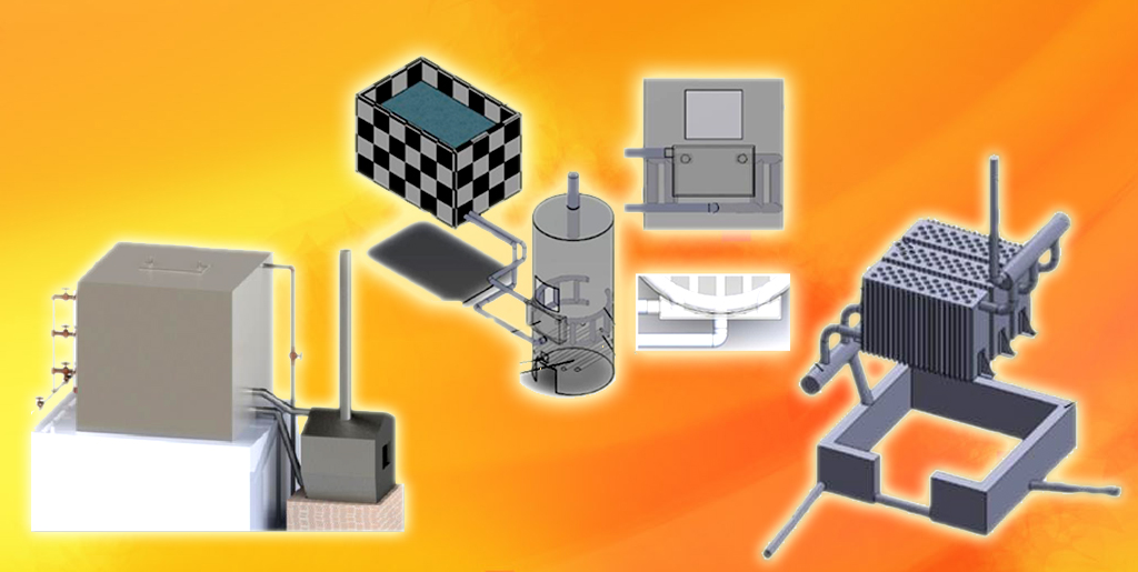
A research team led by Hong Sung Chol, a researcher at the Faculty of Heat Engineering, has developed and introduced various types of energy conservational boilers.
Energy conservational unpowered boiler with a package of fire-tube heaters combined with fin array in box type
The boiler satisfies heat requirements needed for production and heating with a small amount of fuel. It costs little to manufacture and install. It is simple in its composition and principle and easy to reset the load. It has the highest heat output for furnaces of the same volume. In addition, for the same heat output, it consumes a lot less fuel and material than other fire-tube heaters. Especially, it is very convenient to introduce them as they are standardized in 10 heat outputs with seven optimized indicators to ensure the scientific accuracy, economy and promptness of introduction in consideration of its various types and conditions of installation. The boiler makes the most use of the produced heat by preheating water from the heat included in waste ash, by using the flue gas from heating and by keeping boiler walls warm. Compared with conventional boilers of the same furnace volume, it provides three times as much heat output (η=88~93%), consumes less fuel by 1/4 [fuel consumption of 162kW hot water heater: B=100~110kg/d(Qar=20MJ/㎏)] and material by over 1/2, and reduces the number of boilers for a unit heating area.
Energy conservational steam bath boiler
It is made up of the cylindrical body that produces both heat and hot water at the same time by recycling wasted heat, a water heater, a feed water inlet, a hot water outlet, a fuel inlet, a fire-grate and a chimney. The annular upper and lower heaters inside the body and the outer collecting heater and economizer outside the body maintain the temperature of a sauna at over 75~85℃ and produce hot water of 40~50℃ at 2~2.5t/h. (fuel consumption B=40kg/d)
Boiler for hot water tank
In the boiler is a hot water heater in the shape of a nest which is combined with a plate and a water pipe. The hot water system consumes no electricity and is operated by natural ventilation and cycle. It can produce hot water of 65~75℃ at 40~45t/d. (fuel consumption B=60kg/d)
...
Jo Jan 8, 2023
The site of Anhak Palace, a royal palace of Koguryo, covers a large area of Anhak-dong, Taesong District, Pyongyang City.
It was built when the capital of Koguryo moved from present-day Jian, Jilin to Pyongyang. Anhak Palace was for normal times, while Fort on Mt. Taesong was for emergency.
The palace site is surrounded by earthen castle walls. Each side of the square castle is 622 meters. The area of the site is as large as about 380 000㎡. In the castle, 52 palaces stand with the eaves facing one another on the total floor space of 31 458㎡.
A moat was dug outside around the walls of the castle to reinforce the defence. There were three castle gates on the southern wall and one on the eastern, western and northern walls each.
The palaces in the castle were disposed along the north-south central axis.
The palaces constituted five architectural groups ― outer palace, inner palace, bedchamber palace, eastern palace and western palace.
The outer palace was for great state ceremonies and the inner palace was for ordinary state affairs. The bedchamber palace was the king’s dwelling place.
The eastern palace was the Crown prince’s palace, and in the western palace were people serving in the palace and administration facilities. In the palace castle were laid out ponds in various sizes and gardens with artificial slopes. The site of Anhak Palace gives us a glimpse into the excellent architecture of that time. Such system of Koguryo’s royal palaces was introduced into Paekje and Silla, the countries of the same blood, and the later feudal royal palaces of our country.
...


